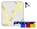
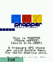
Phapper
updated 8/29: fixed library problem with both versions, so if you experienced any problems installing (verifying) phapper so far, please try again!
A new app from the labs at Gravity Monkey: Phapper. By now you may have figured out that one of the only reasons I like building stuff is so I can name it. Like, for example, the "liver". Who the hell named that? 'Cuz you need it to 'live'? Pretty literal, but nevertheless, must've been fun coming up with that one.
Back to the topic, and not just of rather literal names -- this new app I've got here is a PHone mAPPER. I thought about naming it "Elizabeth's View" after this classic (that is, a view from the heavens), but it got the "I dunno about that..." response from the missus.
Basically, with Phapper and your Nextel GPS enabled phone, you can see Google Maps on your phone [not in all it's AJAX'y scrolling goodness, but as a map, OK?]. Or, if you don't have a Nextel GPS enabled phone, you'll have to type in your address -- or whatever address you want, really. The phone figures out what zoom level and what tiles match up with your position, then grabs a composite image made up of Google Maps' tiles from the server (so you'll need internet access from your phone). Your current position is plotted with a little flag, and older points (if you're using GPS) show up with red squares. As the plots get older, they get lighter -- so you'll leave a trail of ever-lightening GPS spots about the map as you move around.
But, here's the trick. It's free, of course. Because it should be, and because I wouldn't want to step on Google's rights. Hopefully this falls within the sense of "fair use", and "Don't be evil". The other trick to it is that it's based on the tile scheme from the initial rollout of Google maps, before the integration of the Keyhole satellite imagery, which means there are some important caveats:
North America only
Will work only as long as Google Maps chooses to support the plate carrée projection
Thanks to a bunch of folks who documented this stuff --including Jeremy Dunck, Ajay Shekhawat, and a nice explaination of the satellite tiles and the projections from the incredibly talented Mark Pursey.
If you've got a regular old (no GPS) cellphone, you should also check out Cristian Streng's Mobile GMaps, as he includes satellite images and Microsoft's maps, too!
Where to get it? Go to the new Gravity Monkey download page to grab a copy. It's free, so I'll do the best I can as far as installation support and app support -- contact me if you want.
Next steps? Oh, there are plenty. Sharing locations between users, implementing an integration of local data and locations, perhaps through shrunq. Push-style notifications when someone is in your area. Games. Lotsa stuff. Lemme push Shrunq off into release and I'll come back....gimme some thoughts and feedback and I'll see how far we can take this.
Posted by juechi at 10:20 PM
|