 red | blue is now available in three flavors -- the original Nextel GPS version, a version for Blackberry, and a quasi-generic version for any Java/Internet enabled cellphone -- just in time for the stretch run to the election.
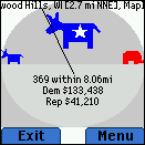
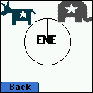 With inspiration and data from Mike Frumin and FundRace.org, red|blue transposes the experience of looking up individual campaign contributions onto a Java-enabled phone. With a GPS-enabled phone, the application will take your current location and figure out if you're in a Democratic area or Republican area. The app will also take this information and plot it around you -- in a compass -- to show which direction the money comes from. It's fun to walk or ride about the city, and see how the money changes -- and see how that's reflected in nature of the neighborhood or your surroundings.
For the many without GPS capability, you can enter in your current address, or your current zipcode to get the same data, if you use either the Blackberry or generic-java-cellphone version. These versions aren't quite tweaked out to optimize for the device, it's more of a general J2ME version that will be subject to the whims of your handset's implementation. You get the idea, tho'. It would seem silly to do something like this without a Blackberry version, right?
You can find out more, and download files for installation. The apps are also available on Handango, which will give you more support and structure to manage the install process -- which is varied by phone and carrier. Use the Free Trial Version -- it's fully functional, no need pay any money (I need to offer a version for $$ so that they will list it). If you install it and run into any problems, or can share any phone or carrier specific tips -- lemme know!


